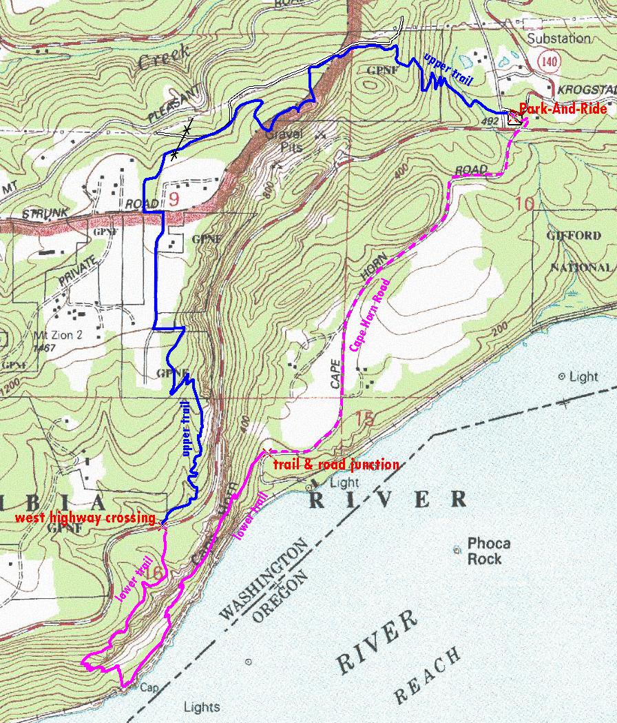
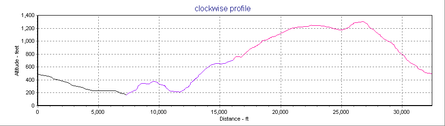
Cape Horn via Skamania Transit The Cape Horn Trail via Skamania Transit

Loop Overview

The complete Cape Horn Loop includes a part above SR14 and a part below SR14. The hiking loop intersects the highway at the Salmon Falls Road Park-And-Ride and 3/4 mile east of milepost 24. The lower part includes 1.4 miles on Cape Horn Road.
overview map

Hiking Options from Skamania Transit

The complete loop can be hiked in 4 hours by strong hikers who avoid long breaks. Counter-clockwise is the preferred direction because it is easy to meet the bus by adjusting your pace on Cape Horn Road. Skamania Transit will drop hikers at the west highway crossing (3/4 mile after milepost 24) so they can hike only the upper or lower part of the loop and meet the return bus at Salmon Falls Road park-and-ride. This should allow plenty of time for a breaks at view spots. If you intend to hike only the upper part you can use extra time to hike to hike out-and-back to lower viewpoints. Hike down the lower trail for about 1/2 hour then turn around and hike back up to the highway. You will see some views from the lower trail and have 3 hours for the upper trail.

Mileage and Elevations

complete
loop
upper
only
lower only
totaltrail onlyroad only
length (in miles)6.13.03.11.71.4
ccw cumulative elevation gain (in feet)1600950650300350
cw cumulative elevation gain (in feet)16007009009000
        
elevation (in feet)
park-and-ride500
west highway crossing700
trail & road junction150 (low point)
Pioneer Point1310 (high point)


Trail Descriptions with time points to meet Skamania Transit

counter-clockwise
clockwise

Elevation Profile

overview map

Links

Skamania Transit schedule and map
Friends of the Columbia Gorge
Portland Hikers trail description

Maps and GPS

Cape Horn.kmz high resolution aerial photo for use with Google Earth
aerial.jpg high resolution aerial photo taken in 2006
tracklog.gpx for use with GPS